New England Before Europeans – the Native Americans

Select your language to auto-translate:

EnglishEspañolFrançaisDeutschItalianoDansk中文(简体)中文(漢字)日本語한국어PortuguêsTürkçeالعربية

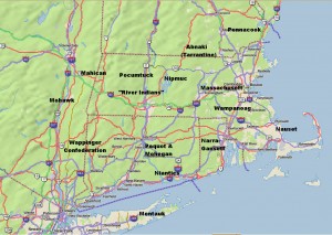
Rough Locations of Primary New England Native American Tribes

Rough Locations of Primary New England Native American Tribes

Map © 2008 DeLorme (www.delorme.com) TOPO USA® – Annotations by the Author

By the time white Europeans arrived, New England had been inhabited by Native Americans for over a thousand years. Migrating here after the retreat of the last ice age, by 1500 they had a population likely in excess of 100,000. Originally hunters and gatherers, they had become more agricultural – with extensive fields of corn (maize), beans, and squash.  By this time the tribes were fundamentally stationary, but shifted dwellings several times year based on weather – winter, autumn hunting, and summer.

The New England tribes had a common heritage and belonged to the Algonquian family. Their language was fairly common, and although each tribe had nuances, there was the ability to be understood from Cape Cod to Canada.

Politically, each tribe and sub-tribe had a single primary ruler, called “sachem” or “sagamore”.  These sachem were usually men, but sometimes there were squaw, or female, sachem.  Within the tribal hierarchy, there were sub-sachems for functions such as the military (for war), powwows (medicine), and other functions.

At the time of the white man’s arrival, there were a number of principle tribes, many peaceful, but some warlike and in competition with their neighbors. The names of these tribes have been inherited by many New England towns, rivers and lakes. Those tribes included:

  • The Abnaki, also known as the Tarrantine to other tribes, inhabited western Maine, especially the Kennebec Androscoggin & Saco River valleys, as well as portions of neighboring New Hampshire. As this is the colder and more mountainous portion of New England, the Abnaki tended more to hunting than farming. More warlike than their southern neighbors, many tribes, and particularly the Massachusetts, lived in dread of Tarrantine raids. They had a reputation for cruelty and were accused of cannibalism by the English.
  • The Penacook inhabited southern and central MA, northeastern MA and southeastern ME, with the principle subdivision around Concord, NH. The Penacook had many subordinate tribes including the Nashua, Piscataqua, and the Winnepesaukee.
  • The Massachusett (in Algonquian, “people of the great hills”), from whom the state of Massachusetts got its name, inhabited the eastern area of state, around Boston. Originally one of the more powerful tribes, it was devastated by the plague and wars with the Abnaki. Their population declined from about 3,000 to 500 between 1615 and 1630.
  • The Wampanoag inhabited the areas of southeastern Massachusetts near where the Pilgrims landed in current Plymouth. They were also devastated by the plague. Metacom (King Philip of “King Philip’s War”) was Wampanoag.
  • The Narragansetts were a powerful tribe that lived in present-day Rhode Island.
  • The Niantics were a largely coastal tribe lived on Narragansett Bay, and extended as far west as the Pequot tribe in Connecticut.
  • The Pequots, of eastern Connecticut were originally part of the Mahican (known as Mohegan, a corruption of the Mahigan name) a tribe of the of upper Hudson River valley in New York.  They were warlike and aggressive and the primary protagonist in the Pequot War in 1637-1638.
  • The Nipmucs who inhabited central MA, were a comparatively weak tribe who frequently paid tribute to their neighbors.
  • The Pocumtucks were a loose association of tribes that lived west of the Nipmucks in the areas around Deerfield, MA.
  • South of the Pocumtucks along the Connecticut River Valley lived the “River Indians”, another loose association of tribes.
  • Bordering the River Indians to the west was the Wappinger Confederacy, which extended from the west bank of the Hudson River as far south as Manhattan and north to Poughkeepsie. Tribes of the Wappinger included the Mattabesic, Quinnipiac, Paugusset, and Tunxis.
  • North of the Wappinger Confederacy were the Mahicans, (Mohecan), the parent tribe to the Pequots. They inhabited the western Connecticut and the upper Hudson Valley in New York.
  • The Nausets were a smaller tribe that lived on Cape Cod.
  • The Montauks inhabited eastern Long Island.
  • The Mohawks, who spanned most of eastern New York State, were the easternmost tribe of the Iroquois confederacy, e.g., they were not Algonquin. Extremely warlike, they were formidable and feared by the Algonquin tribes.

Between 1616 and 1619 a plague, or the “Great Dying,” wiped out almost ¾ of the New England Native American population, with the devastation worse in the coastal areas where mortality was as high as 95%. A major effect was that when white settlers began arriving, starting in 1620, they encountered very little of the indigenous population. The Native American’s ability to resist the Europeans was very weak.

For Part 2, the Early Exploration of New England, click here.

Sources and for additional reading:

Bragdon, Kathleen Joan, Native People of Southern New England, 1500-1650.  University of Oklahoma Press, 1996.

Vaughan, Alden T., New England Frontier Puritans and Indians 1620-1675.  Little Brown and Company Boston, 1965.

http://iweb.tntech.edu/kosburn/History-201/Puritans%20&%20Indians.htm

http://www.memorialhall.mass.edu/classroom/curriculum_6th/lesson2/bkgdessay.html

http://www.smithsonianmag.com/history-archaeology/squanto.htm


Freedom Trail Maps with Google Map Tour

Any visitor to the Freedom Trail and Colonial Boston will need good maps.  Here are several – all free.

The Google map below was created for the eBook Freedom Trail Boston – Ultimate Tour and History Guide. In itself, the map is almost a full tour guide and includes the essentials for all the official, as well as many interesting unofficial Freedom Trail sites. All of the Official Stops come with web-based auto-translate links that allow the user to specify the language for the post. A great feature for non-English comfortable users.

The map also provides information such as operating hours, websites, phone numbers, admission costs and handicap access notes.  There are even listings for the best historic restaurants. Here is a video post that includes all the sites listed in the map.

The map is also available as a FREE full-blown Android app, downloadable from Google Play as well as from the Amazon App Store. The app exposes all the best features of Google Maps and is, by far, the most usable way to use the map. It  performs better than using a browser, is much less awkward, and lets you keep the map easily identifiable and ready to launch.

Use it (at your own risk as travel information is subject to change), enjoy it, and please comment.  Pass the link on to your friends.

View Freedom Trail Map & Historic Boston Guide in a larger map


Next is a series of official Freedom Trail maps from the US National Park Service (NPS).  These are savable, printable,  well done and all paid for by US tax dollars.

The main Freedom Trail Map, which is the same that you will see on the NPS Freedom Trail Guide paper guide, is available here.  It is also available from The Freedom Trail Foundation here.  Additionally, there are other relevant visitor maps available from the National Park Service – for the whole series click here.  In addition to the official Freedom Trail map mentioned above, there is a less detailed Freedom Trail map with an outline of Boston’s harbor line at 1775 – fascinating for historical context.  Click here for the 1775 overlay map.  The series also includes maps for the Charlestown Navy Yard,  Boston Harbor in WW II, a map that shows walking distances between Boston sites (Boston is a very walkable city), and a guide for tour bus parking.


Paul Revere, George Washington and John Adams Face to Face at Boston MFA

The Boston Museum of Fine Arts is awesome, and it’s the only place you can see some of the most influential leaders of the American Revolution up close and personal.  John Singleton Copley’s vivid and compelling portraits of Paul Revere, Sam Adams, John Hancock and Joseph Warren are intimate and perceptive.  Gilbert Stuart’s works of George Washington are superb, and you can even see the original portrait used as the model for the U.S. one dollar bill.  This is as close as you can get to shaking hands with these leaders of the American Revolution today.

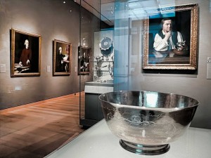
Revere’s Sons of Liberty Bowl with Copley’s Portraits of Revere, Samuel Adams, John Hancock, & Dr. Warren

Located on the first floor of the MFA’s Art of the America’s Wing, the first thing you meet upon entering the gallery is Paul Revere’s 1768 “Son’s of Liberty Bowl.” The silver bowl was commissioned by fifteen members of the Sons of Liberty to honor the Massachusetts House of Representatives for standing up to the British after the Townshend Acts in 1767.  The chain of events set off by the Townshend Acts, and the troops Britain sent to quell the associated Colonial turbulence, was to lead inexorably to the Boston Massacre in 1770 then on to the American Revolution.

The Townshend Acts taxed imported commodities, including paper, glass and tea.  The Massachusetts House of Representatives sent a “Circular Letter” to other colonies asking for their support to protest the Acts – which resulted in boycotts of British goods by Royal colonies.  In Boston, resistance was so intense that British custom officials requested military assistance.  After the HMS Rodney, a 50-gun warship, arrived in Boston harbor, the Colonials rioted and Britain sent 4 regiments of troops to restore order. The presence of the troops led directly to the Boston Massacre.

Directly behind the bowl is Copley’s 1768 portrait of Paul Revere, painted when Revere was thirty three years old.  The portrait was unusual for the period, as it shows Revere without the traditional gentleman’s coat and wig.  (Revere’s family thought it made him look like a workman and actually hid it in the attic.)  The portrait works on many levels, both as a discerning picture of Revere and as a political statement.  Note Revere’s flaunting display of flowing linen shirtsleeves – the linen was manufactured in Boston in direct defiance of British laws.   Flanking the portrait are two cases of Revere’s silver – incredible works of art on their own.

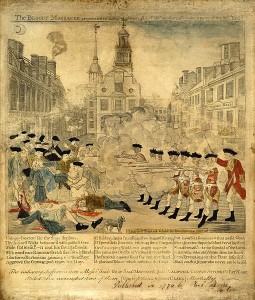
Paul Revere’s Engraving of the Boston Massacre

On the wall to the left of Revere’s portrait you will find four important Revolutionary works, one an engraving and three Copley portraits of Boston revolutionaries.  The engraving is Paul Revere’s highly sensationalized depiction of the March 1770 Boston Massacre.  The Massacre took place after an unfortunate chain of events led British soldiers to fire on an angry Boston mob, killing five and wounding six.  Although hardly a massacre (most of the soldiers were later acquitted of blame) it was to be an important event provoking colonial unrest.  The famous engraving you see was a key piece of Patriot propaganda used to help move America closer to its break with Great Britain.

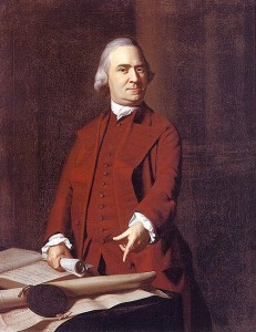
Sam Adams at 50 in 1772

Next is the 1772 portrait of Samuel Adams.  Adams is shown defiantly pointing to a petition from angry Boston citizens after the Boston Massacre.   The portrait was commissioned by John Hancock to hang in his Beacon Street mansion which was located at the southwest corner of the current Massachusetts State House site.

John Hancock at 28 around 1765

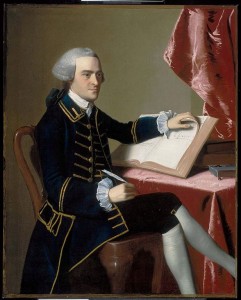
Next is John Hancock himself, painted in 1765 when he was twenty-eight.  Hancock is best known for his flamboyant signature on the Declaration of Independence, and he was a multidimensional architect of the Revolution.   A successful merchant, he was one of the richest people in America and personally funded much of the Boston-based dissension.  He was president of the Massachusetts Provincial Congress (the Patriot shadow government that was formed after the Boston Tea Party in 1774), the second Continental Congress, which created the Declaration of Independence, and later served as the first Governor of the State of Massachusetts.

Joseph Warren at 24 around 1765

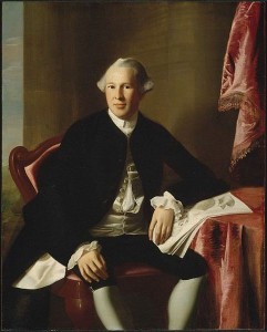
Further down the wall is the sensitive portrait of Dr. Joseph Warren at the age of twenty-four, also painted around 1765.  Warren was one of the most influential Patriot leaders, and served as President of both the Massachusetts Committee of Safety and the Provincial Congress.   After the April 1775 Battles of Lexington and Concord, he strongly advocated going to war with Britain.  Even though he had limited military experience, he was appointed a major general.  He died fighting as a private during the Battle of Bunker Hill on June 17, 1775.   John Trumbull’s painting “The Death of General Warren at the Battle of Bunker’s Hill” is shown elsewhere in the exhibit.

The exhibition features a number of other Revolutionary-themed works including Copley’s 1796 portrait of John Quincy Adams, the son of John Adams and the sixth President of the United States, and John-Antoine Houdon’s 1789 portrait of Thomas Jefferson.

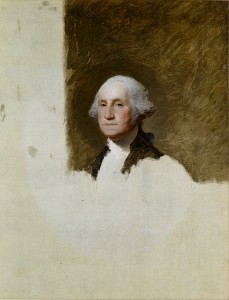
George Washington at 64 “The Athenaeum Portrait” – on the U.S. One Dollar Bill

The next exhibit room features some monumental works by Gilbert Stewart, including the 1796 unfinished portrait of George Washington, known as “The Athenaeum Portrait.”  This painting was used as a model for more than fifty other works, including the image on the U.S. one dollar bill.  Also displayed are Stuart’s portrait of Martha Washington and his idealized 1806 painting of Washington at Dorchester Heights.

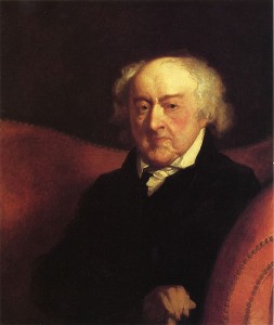
Other Revolutionary works in the same exhibit include Thomas Sully’s 1819 huge painting “The Passage of the Delaware” and Gilbert Stuart’s 1805 painting of General Henry Knox.  General Knox led the expedition that brought the cannons used to lift the Siege of Boston.  He then became chief artillery officer of the Continental Army and later Washington’s Secretary of War.  Stuart’s 1823 portrait of John Adams, ninety at the time of the painting, rounds out the exhibit.  Look into Adams’ tired, sensitive eyes.

Stuart’s John Adams at 90

In all, the five rooms of this gallery contain a treasure of colonial furniture as well as many other important paintings from the 18th and early 19th century colonial America.   Visit and enjoy, whether you are a Revolutionary War enthusiast or not.


Photos of Paul Revere Bowl and Gallery Entrance showing Paul Revere and other Copley portraits, stevestravelguide.com – all rights reserved.

Other pictures from Wikimedia Commons – these works are considered public domain in the United States, and those countries with a copyright term of the life of the author plus 100 years or fewer.


Boston Founding Enabled by Innovative 17th Century Corporate Buy Out

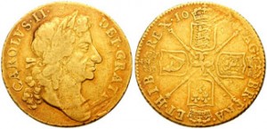
Guinea from reign of Charles II

As described in my entry on Henry VIII’s influence on the founding of Boston, life in the 1620’s England was becoming very difficult for English Puritans.  This was compounded by extremely difficult economic conditions in the areas of England many Puritans called home.

One group of Puritans, led by John Winthrop, a prosperous lord of the manor of Groton, East Anglia, decided it was time to leave.  Realizing that they were unlikely to receive a land grant from the King, they had to find a way to obtain a grant via non-traditional means.  And ideally, so they could build their ideal society, the land would be free from London’s interference in their affairs.  This was a tall order.

It turns out that in 1628, King Charles had given a royal land grant to the New England Company, who represented a group of merchants who wanted to establish mines and trading posts on the Atlantic coast.  The corporate rights of the New England Company were spelled out in the “Charter of the Colony of the Massachusetts Bay in New England.”  The Charter had a very interesting omission – it did not stipulate out where the governor (the equivalent of the modern day CEO) and his assistants (the board of directors and management team) were to hold their meetings.  At this time, it was standard operating practice for the management of a company to be in London, and the worker bees to be in the new world operating by remote control – across three thousand miles of stormy ocean.

The grant was for a substantial parcel of land that ran from the Merrimack River, about 40 miles north of Boston by modern day Newburyport, to the Charles River, which runs through Boston.  And, the parcel ran from “from sea to sea.”

In a move very unusual for this time period, Winthrop and his Puritan supporters bought out a controlling interest in the New England Company from the existing shareholders.  To assure themselves the ability to govern free from royal interference, they had the company transfer its management meetings from London to America.  Furthermore, they decided that only those people who were willing to leave England could become shareholders and required that existing shareholders who did not want to move to America sell their shares.  John Winthrop was elected governor and the entire operation, including the physical charter document, moved to America.

This land grant and its innovative corporate charter was the perfect vehicle to use as the foundation for the Puritans’ wide-reaching and ambitious social experiment in the new world.   It was to provide the foundation for the wide range of independent thought and action that was fundamental to the development of Boston and the philosophies leading to the American Revolution.

Guinea photo from the Classical Numismatic Group, GNU Free Documentation License, Version 1.2 or later.

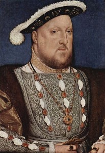
Henry VIII’s Critical Influence on Boston’s Founding

There is an amazing linkage between Henry VIII (king of England from 1509 to 1547) and the founding of Boston. In his quest to produce a male heir, Henry wanted to divorce his first queen, Catherine of Aragon. The pope refused to annul the marriage, so Henry drove what became known as the English Reformation (+/-1530) by which the Church of England broke away from the authority of the Pope and the Roman Catholic Church. (Henry’s motives were also political, but that is another story.)
When England broke with the Catholic Church, many different Protestant sects vied for power. After Henry’s death, his daughter, Queen Elizabeth I (the Virgin Queen, reigning 1558-1603), set out to eliminate the “foolish theological quibbling” among the Protestant sects by formalizing the Church of England (Anglican Church) as the official church and instituting Penal Laws to enforce compliance.
The Church of England retained many of the trappings and hierarchy of the Catholic Church, which many English Protestants abhorred. Some dissenters joined the Church of England and worked to “purify” the church from within, becoming known as “Puritans”. Some refused to join church, and became known as “Separatists.”
Elizabeth’s successors, James I (rule 1603 – 1625) and his son Charles I (rule 1625 – 1649), made things particularly uncomfortable for the dissenters and were zealous in enforcing conformity to the Church of England. The persecution inflicted on the non-conforming Protestant approaches prodded two key groups to leave England in search of religious freedom and found settlements important to Boston history.
The first group of dissenters were Separatists, who after departing England for Holland in 1608, left for America 1620 and founded Plymouth, about 40 miles south of Boston. This group was relatively poor and agrarian.
The second group was more affluent and included sophisticated merchants and businessmen. Led by John Winthrop, they sailed from England to New England in 1630 with the ambitious mission to create a new society, a “city upon a hill” (reference from Jesus’ Sermon on the Mount), that would be watched by the world. This new kind of society would balance both civil and ecclesiastical dimensions for the good of the public – guided by God and the Bible. This group landed near present day Salem, MA, about 20 miles north of Boston. They then moved south and founded Boston, named for a town near their home in Lincolnshire, England.
Would Boston have been founded if Henry had not wanted a male heir? Over time, there would have certainly been an important city at site of present-day Boston.  However, it would not have been called Boston, and it would not be close to the city we know. The Puritans, their culture, their society and even their form of governing was instrumental to the character of early Boston, the American Revolution, and lives on to this day. Thank you, King Henry.